|
Detailed account
Click to go to
Introduction
Chapter
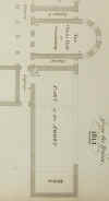
House
Dormitory
Original
walls
Cellar
Ground
floor west wall
Ground
floor east wall Ground
floor south wall
First
floor dormitory proper
Historical
evidence
Reredorter Reredorter
historical evidence REFECTORY South
elevation North
elevation PASSAGE
TO CLOISTER Door
into cloister Door
from dormitory stairs IMAGES
AND WRITTEN DESCRIPTIONS
INTRODUCTION
This section of the Reading Abbey website attempts to identify original features in the Abbey Ruins
especially those which are being conserved in the Lottery Project, that is the dormitory and reredorter, and interpret how they were part of the original or later buildings. Other buildings of the abbey especially the church, chapter house and refectory have been discussed recently in Baxter R 'The Decoration of the Cloister at Reading Abbey' (with Stuart Harrison), in Keen, Lawrence and Eileen Scarff (eds.) Windsor: Medieval Archaeology, Art and Architecture in the Thames Valley, Transactions of the British Archaeological Association, XXV (2002), 302-12. Baxter R 'Reading Abbey: the Architecture of the Abbey Church' (with Malcolm Thurlby), ), in Keen, Lawrence and Eileen Scarff (eds.) Windsor: Medieval Archaeology, Art and Architecture in the Thames Valley, Transactions of the British Archaeological Association, XXV (2002), 282-301. The
Corpus of Romanesque Sculpture in Britain and Ireland website http://www.crsbi.ac.uk/crsbi/frbesites.html
also discusses the original abbey.
The text that follows comes from inspection of the ruins by Leslie Cram with Bob Hill and Ron Baxter and Leslie Cram has examined and read every original image or text as itemized in the bibliography. The conclusions suggested here are
put together by Leslie Cram who is solely responsible for their
accuracy. They are provisional and await further work and discussion with others.
Images and textual accounts are
predominantly to be found in the Local Studies Collection at Reading Central Library - for more
images, visit the website - www.readinglibraries.org.uk - and click on "catalogue".
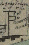
They include the earliest map of Reading by Speed in 1610 which shows
the Abbey but stylized more than as actually observed.
THE CHAPTER HOUSE A
detailed description of how the Chapter House originally looked is to be
found on the Reading Abbey page on the Corpus of Romanesque Sculpture in
Britain and Ireland website http://www.crsbi.ac.uk/crsbi/frbesites.html.
It was entered by a door from the east walkway of the cloister with
windows on either side. Above these were three windows, the central one
over the door being higher. These let light into the Chapter House above
the roof of the cloister walkway. Englefield's elevation of 1779 shows
this. The arches of all six of these openings have been rebuilt in
recent conservation work. The sides of the central door have been
reconstructed in a way different from the original with flint forming
circular pillars. Originally this door would have had ornate limestone
decoration. The layout resembles that to be seen today in Durham.
Inside the Chapter House we would have seen, when standing just inside
the entrance door, stone seats on either side of which some of the
flint core remains. The east end, at the level of the upper windows in the west end, had five windows. The openings for all these
survive but the arches of the four to the north have have disappeared. Below the central window the
wall has been broken through in post Abbey times to make an entrance.
Holes in the walls remain from a small door in the north-west corner into the slype or
passage below the Treasury and another small door at the south-east
which led to
the outside of the Chapter House.
The
Chapter House was roofed with a semicircular barrel vault of stone,
which is noted by Englefield as including the lightweight type of stone
called tufa. The Chapter House internally was constructed with a
skin of limestone blocks over the flint rubble inner core but these
blocks have been taken away for buildings elsewhere. The negative
hollows can be seen for these blocks in the remaining flint walls
and also the evidence for the architectural columns and decoration,
discussed in full on http://www.crsbi.ac.uk/crsbi/frbesites.html.
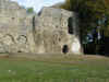
THE DORMITORY.
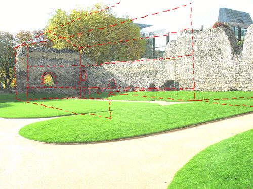
ORIGINAL FLINT FACED AND PLASTERED WALLS.
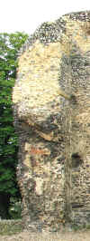
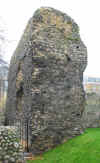
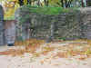
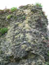
The walls of the dormitory are predominantly of flint. This flint is
usually set as a smooth surface. The surface often has the flint in horizontal courses
with the flint knapped to present a smoother surface which are interpreted as being the original Abbey surface. It is assumed that in Abbey times this flint surface was plastered. Areas of Victorian or recent maintenance work can be identified as they show the flints located haphazardly rather than in
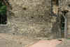
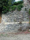
courses and or the flints do not present a knapped surface. Where the flint has been reset in courses resembling the medieval the examination of the mortar could differentiate. This smooth flint surface contrasts with the usual surface of the Abbey buildings to the north, the church, the chapter house and cloister. Here the surface in Abbey times was faced in limestone blocks (ashlar). In places these limestone blocks remain complete or as fragments. Where the block does not remain it has been robbed away for later reuse and it is usual for there to be a negative impression, a hollow in the rubble core where the block was set. The contrast between the plastered surface and the ashlar surface can be seen on the south wall of the chapter house. Here the wall on the west within the dormitory building was flint faced, the wall on the east was visible from the outside, originally ashlar faced, and shows negative impressions.

CELLAR.
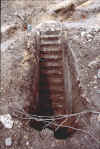
The soakaway dug in the centre of the dormitory grassy centre during the Lottery work,
and indications on the walls suggest that the original building had three levels. The soakaway is interpreted as dug through manmade backfill. At its base is a mortar level which is interpreted as the floor of a crypt or cellar. This level is approximately at the level of the Kennet a few yards to the south. A second world war air-raid shelter has recently been discovered excavated into the dormitory. This had been filled with rubble before being buried and was not examined internally. The north wall of the cellar may be shown on Man's 1813
map where there is a foundation shown running east-west following the line of the south wall of the refectory.
This would mean that the whole site south of the cloister and refectory
and the chapter house was landscaped in the building of the abbey to
make a terrace against which was constructed the south wall of the
refectory and the north wall of the cellar of the dormitory
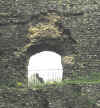
building. Man says of what we now call the dormitory on page 251 "This wing probably consisted of the offices, as there appear to have been arched cellars under the whole range, and at the south end was the kitchen, as is supposed from the spot being called Kitchen end". It is surmised that to the south there was an entrance at the level of the Kennet for goods to be brought in from the nearby Abbot's wharf. This may have been at the south-west corner under the existing arch or below the arch in the south wall. Light for this cellar came from windows in the west wall which now remain as arches at its base, visible from the east and west elevations.
In some cases the top of the arch has collapsed taking it above the level
of the top of the cellar. The most southerly of the arches has been blocked on the west side of the wall but inspection inside tells us that the light entered in a light shoot diagonally from the west. The courses of flint above and to the side of the arch are continuous and these are interpreted as being original. This would make the original window top circular or Norman in shape and dating to the original build of the Abbey. At the south of the west wall is the modern archway with the wooden pillar. The interpretation is of an arch to the window or door of the cellar below and offset to the north of the upper arch.
On the south wall of the dormitory a step in the flint appears to be at the same level as the top of the southern most window in the west wall and showing where the wood of the ground floor, the ceiling of the cellar, rested. This step is also seen on the west dormitory
wall just north of the entrance arch. The step in the flint is not seen to the east on the south elevation and the return of the east wall but the flint shows a collapse and lack of neat courses at the level below the step. The arch in the south wall is filled in with haphazard recent flintwork at its base.
It is possible that there was an entrance into the cellar at the river level, below the arch in the south wall and the present ground surface, entered through a passage (now filled up) between the south wall of the dormitory and the north wall of the reredorter. There is evidence of an arch over such a passage at the west. Evidence for an arch to a passage is absent from the east. The 1879 map shows this passage between the south of the dormitory and the north of the reredorter, but earlier maps show the
reredorter built directly onto the south wall of the dormitory. This cellar under the dormitory with a possible entrance at river level from the south compares with the cellar under the buildings on the west side of the cloister range which may have had an entrance at
ground level south of the refectory wall (Fasham, P J & I J Stewart, 1991, Excavations at Reading Abbey, 1985-6, Berkshire Archaeological Journal 73, 1986-90, page 101).

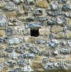
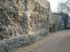
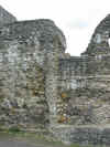
GROUND FLOOR, WEST WALL
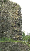
The remaining dormitory walls are predominantly of the ground floor rooms where traditionally the warming room/parlour was located. Put-log holes for scaffolding can be seen in the east
and west elevations of this wall . Put-log holes can be identified by being constructed of a long thin flint or limestone/sandstone lintel above with its either end resting on stones making the sides. The width of the resulting square hole is approximately six inches. The hole was therefore kept permanently open and the scaffolding could be inserted and removed at will. Sockets for beams or corbels had the stone fitted up to the wood and upon its removal the edges are likely to have started to collapse. In places the distance between an upper and lower line of
put-log holes, the scaffold lift, can be seen on the west wall, eastern aspect. This is normally today the distance between the feet and chest height and appears to be the same on the west wall. The arch of
the second arch going north along the west dormitory wall appears to have a more or less original crown and some indication of a pointed and therefore later arch for a door or window to the ground floor.
The courses of flint in the elevation of the west wall viewed from the
east are horizontal.
There is much collapse of the original outer flint courses and patches of recent resetting of
flint on the west elevation of the west wall, where the modern path leads down to the Kennet from the chapter house
. The courses of the flints making up the outer surface of the elevation
of the west wall viewed from the west follow the line of the ground
surface, sloping downwards from north towards the Kennet at the
south. Englefield's elevation in 1779 stops just after the
door by the refectory steps but shows the flintwork beginning to slope
southward.
The arch at the south-west of the dormitory on the ground floor appears to be from a window to the ground floor. The limestone blocks on the east side of this arch are original and incidentally are the sharpest and best preserved of any limestone in situ in the ruins of Reading Abbey. Springing from these limestone blocks is an arch which has been surfaced in Victorian or later times with plaster running into and down the north side. This plaster has broken away
and shows roof tiles used as voussoirs to make the arch. The use of Roman tile in building in Norman and earlier times is well known (from Brixworth and St Albans for instance) and Roman tile has been observed making up the rubble of the inner core of the walls of Reading Abbey. The simple curve of this arch together with the tile suggests that the arch is from the original Norman construction using Roman tile. However the tiles appear thin for Roman and may be mediaeval or later repeating the curve of the Norman arch. The opening below the arch is thought to be from collapsed flint between the window or door at the level of the cellar and the upper window.
On the west side of the west wall, outside the dormitory building, is indication of a buttress or the stub or return of a wall running west. This stub is shown on the 1879 OS map.
An engraving by Havell of 1830 of the reredorter and this wall viewed from the south appears to show a lean to building in this position. At the top of this west elevation of the west wall is a step in the flint work and a sequence of sockets or
put-log holes. These are interpreted as a floor level which could relate to the 1830 Havell building. The date of this is unknown.
GROUND FLOOR, EAST WALL
Jutting out from the south wall of the chapter house and from the south wall of the dormitory
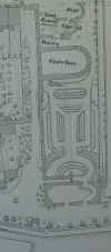
are the stubs of the return of the east wall of the dormitory, the foundations of which are presumed to lie below ground in the central grass area of the dormitory as shown in the Man's 1813
map and 1879 OS map. Other maps and maps show only a property boundary (Coates) or nothing (Englefield and 1834 and 1853). The northern of these two returns, in the south wall of the chapter house is 9 paces to the east of the west wall, the
return in the south wall is 11 paces. The two returns therefore did not meet if the were built strictly at 90 degrees from their parent walls and there must have been some intermediary making up of the two paces discrepancy. Running east-west and to the south of the chapter house was a passage or slype matching that to the north. It seems the most likely that the east wall of the dormitory was foursquare up to this passage wall and the east entrance to the
slype was set back by two paces. Man's 1813
map shows the foundation of this wall making a foursquare shape and going up to a south wall of the passage to the south of the chapter house with the stairs to the dormitory proper in its northwest corner. The 1879 OS map shows the foundations of this passage wall and the foundations of the east wall of the dormitory. The 1853 survey shows a property boundary but no standing passage wall. If the warming room was in this ground floor area as has been supposed, we can say that its windows faced east and its fireplace and chimney were in the east wall which has now collapsed. The entrance from the slype into the cloister and the layout of the stairs is discussed further below.
This east wall on its east elevation shows a distinct horizontal line which separates the south side with negative impressions from removed ashlar facing stone and the north side which retains original courses of flint.
This ashlar on the corner of the building can be explained as functional
to provide stability to the corner which flint could not provide. A
comparison can be made with churches built of flint where the corners
have limestone or other ashlar blocks. The return of the east wall as it leaves the south wall shows a window.
GROUND FLOOR, SOUTH WALL
The arch or door in the south wall north elevation has haphazardly positioned replacement flints making its top, but the stone of the arch may be original. We have already seen that the base of this arch is not original. Half way up the wall to its west part of a corbel remains set in tile. From the south side of this south wall the arch can be seen to have continuous courses of flint running towards its top although there has been much collapse of the outer courses. On the east side of this arch may be an original roof line wall. This roof line may be visible in Havell's 1807 oil painting. On the east edge of this wall is
what appears to be a buttress beside a robbed out wall stretching south. There is a corresponding return on the west side. Both of these returns are shown on the 1853 survey and the 1879 OS map. The south elevation of the south dormitory wall is shown in Havell's 1807 oil painting and his 1830 engraving.
FIRST FLOOR, DORMITORY PROPER
At the south end of the west wall viewed from the east is a stringcourse of original limestone to take the timbers of the ceiling of the warming room at ground floor level, the floor of the dormitory proper, running east and west on the first floor. At the southwest corner the string course has a corbel remaining set into tile. The stringcourse is also found on the east wall stub. A stringcourse on its east elevation is at a higher level, not built through the thickness of the wall. The
west wall of the dormitory proper on the first floor is missing at its
southern extent. Where it stands at the north it could be almost to its
original height. The suggested interpretation is that the missing
stretch contained windows and these have collapsed or perhaps been taken
down for reuse elsewhere. The window surrounds and tracery would all
have been of limestone set in the flint walls. A similar argument might
apply to the east wall of the dormitory, missing now and in even the
earliest accounts. If this had many windows along it entire length
it would have been susceptible to collapse.
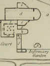
HISTORICAL EVIDENCE
In the past the dormitory was first identified as running along the west side of the cloister. Englefield in 1779 puts the dormitory on the west of the cloister
- "h, The proper situation of the dormitory now a manufactory". It is shown similarly in Man's
map of the abbey at the dissolution where it is marked "l". The area now called the dormitory is "k" and identified as the kitchen "as is supposed from the spot being called Kitchen end". Man's 1813
map calls the present dormitory "part of the Abbey", the reredorter is called the kitchen with foundations of an east west wall following the line of south wall of the refectory. In Coates 1802 map the area now identified as the dormitory is called "L a wall once enclosing rooms". There are gardens to small houses in the area marked O on the Coates version of the Englefield map to the east of the present dormitory. This location of the dormitory on the west of the cloister continues into the 1879 OS map. The present location of the dormitory starts with Hurry in
1901 (Hurry J B 1901, Reading Abbey, London: Elliot Stock).

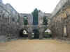
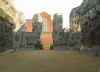
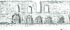
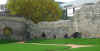
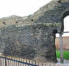
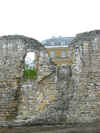
THE REREDORTER OR TOILET BLOCK
The walls of this structure exist to some six feet high. A central entrance on the south wall into the reredorter is shown on the 1853 and subsequent maps. An entrance to the west of this is shown open in the 1853 survey, but blocked in 1879. There is
today a wall built north/south across the toilet block to make a compound. This appears on the 1931 OS map but not on the 1879 nor the 1853
map. The entrance from the south to the east of this Victorian wall is shown in all maps. On the 1853 map there is no break in the wall to the
north: the north break is shown in the 1879 map. The outer faces of flint of the reredorter show no negative impressions of removed ashlar; evidently the building was constructed as the dormitory to its north with walls faced with courses of flint.
Internally all the four the corners have been thickened by building diagonally across. This thickening suggests an industrial use of the building carrying weight rather than just a toilet block. It is possible that this diagonal thickening of the walls was carried out in post Abbey times; further inspection is needed. At the east and the west ends of the south elevation of the reredorter are returns of wall stretching south, or possible buttresses
. These are shown on the 1879 OS map.
REREDORTER HISTORICAL EVIDENCE
The reredorter building is not shown by Englefield who has the abbey buildings terminating at a wall at the south end of the dormitory. The Coates 1802 general map shows it is as part of buildings extending beyond the dormitory walls and with some yards of land between the reredorter and the Kennet. Coates does not identify it as part of the Abbey. The 1642 civil war map is hard to interpret but shows extensive buildings as in Coates 1802 but indeterminately positioned. It may be shown on the Havell 1807 and 1830 views but if
so as buildings only at ground level. The building is first identified as part of the Abbey on Man's map of the Forbury at the dissolution where it is identified as "k supposed the infirmary" and is shown as a size known today and on his 1813
map where it is only as wide east to west as the dormitory and is marked "Kitchen" and the south wall of the dormitory is shown only as a foundation. Constable's 1821 drawing shows the area of the chapter house sweeping down to the Kennet and upon close inspection may show details of the reredorter. The 1834 map shows a complex of buildings as in Coates 1802. Was the building not identified as part of the Abbey by Englefield and Coates because it was lost in the other later buildings added to it? It articulates somewhat awkwardly onto the south of the dormitory; is it a later building and not originally from the abbey? It differs from the other abbey flint walls by the thickness of its walls especially the strengthening of the corners internally. It is Hurry who first identifies it as the reredorter, drawing it as it appears on the OS map and saying, "doubtless a branch of the Holy Brook ran beneath these Latrines and served as the main drain of the Abbey
(Hurry J B 1901, Reading Abbey, London: Elliot Stock. page 13). A watching brief in 1993 found a drain a metre wide running on the inside of the south wall with flint walls extending at least a metre below ground surface,
presumed to have carried water from the Kennet as suggested by
Hurry. (Cram forthcoming in the Berkshire Archaeological Journal and Reading Museum accession number 1999.178).
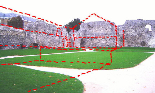
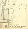
REFECTORY
SOUTH ELEVATION
The south wall of the refectory runs from east to west with a high pillar at its east end where it joins the present path from the cloister to the Kennet. This pillar has negative impressions from removed ashlar facing stone with some of the ashlar blocks still in place on the south, north and east elevations.
The use of ashlar on this corner of the refectory, as at the south east
corner of the dormitory, was necessary to give solidity to the corners
which flint alone could not provide. There may be evidence for a flue having been made in the flint work on the south wall of this pillar and lean-to buildings were constructed against the south wall
( Slade C F 2001, The town of Reading and its Abbey, privately printed, page 143, Tomkins view no. 6, Havell Reading Abbey oil painting 1807). The south elevation of the wall to the west of the pillar does not have the negative impressions from removed ashlar facing stones but rather shows the original outer face of courses of flint, with a consolidating line of ashlar
blocks.
The refectory has been discussed in the recent publications Baxter R 'The Decoration of the Cloister at Reading Abbey' (with Stuart Harrison), in Keen, Lawrence and Eileen Scarff (eds.) Windsor: Medieval Archaeology, Art and Architecture in the Thames Valley, Transactions of the British Archaeological Association, XXV (2002), 302-12
NORTH ELEVATION
The north side of the wall is almost entirely faced in recent brick up to the pillar at the east end which has negative impressions from removed ashlar facing stone with some of the ashlar blocks still in place on the north elevation as on the south. Images exist of the internal east wall of the refectory in 1778 and surveyed by Englefield in 1782 (H. Englefield, 'Observations on Reading Abbey', Archaeologia, 6 (1782), 61-66). Presumably this wall articulated with the present wall at the existing return at the extreme east of the north elevation. There is a step in the flint suggesting a cellar beneath the refectory floor at this position. Ashlar blocks remain in situ or have negative impressions, presumably from the internal wall of the refectory being ashlar faced as was the inside of the chapter house.
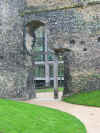
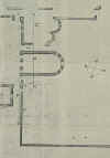
PASSAGE TO CLOISTER
Door into cloister
There are indications of an arch between the pillar marking the east end of the refectory wall and the dormitory wall of a passageway going south to the river following the line west of the dormitory. Tomkins view no 6 of 1791 shows a Norman arch here blocked in to make a doorway and the 1813 ground
map of Man shows the butt of walls at the north and the south end of the refectory east wall. Englefield's 1779
map identifies the area between the east wall of the refectory and the west wall of the dormitory as "K A vaulted passage". Man in 1813 calls this area a passage. Havell's views from the south in 1807 and 1830 show this arch but not blocked in to make the doorway as in Tomkins.
The question must be faced of how
the ground surface was built to the south of the door at the south end
of Englefield's vaulted passage, the door in the Norman arch illustrated
by Tomkins. Did the ground surface rise gradually from the south as it
does today to make a ramp up to the level of this door. Or were there
steps? Today the courses of the flint making up the wall on this side
more or less follow the ground surface to south of the door. The
ground surface today is cut back into the level of the cloister
that extended in Abbey times up to this door. Examination of the
present west elevation of the wall will show the step in the wall
continuing the level of the cloister as found at the entrance to the
Chapter House up to this south door. We suggest the interpretation
that the ground surface south of the door is the original level used for
the courses of flint to follow, though no doubt somewhat built up by
successive resurfacing. There must then have been steps up to the arch
and door into the tunnel.
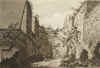
Door in passage at the south of the stairs to the dormitory
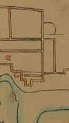
Englefield's text (repeated in Coates on page 274) reads "Going southwards round the outside of this building (the chapter house) we came to a small door and near it the remains of a staircase. The door opens into a dark passage once vaulted, communicating with the cloisters by a great door" (page 63). This elevation "Section through the Line a to ß" shows from north to south
five doors:- the door to the treasury, three chapter house doors, the door to the slype (apparently blocked in at that time) running along the south wall of the chapter house and a further door south of the staircase. This door south of the staircase is his small door in the text. Coates's and Man's
maps based on Englefield also show a door in this position. Man on page 251 says of this ". . . the entrance being through an arched passage, which could have received no light, except from the extremities, and therefore is not likely to have been the principal entrance to this superb abbey. This passage which is 46 feet long and 15 wide, opens into the south-east corner of the cloisters, and was probably intended as a private way for the monks. On the right hand of the passage is a door-way leading to the apartments, and within it is a circular stair case leading to the upper part of the building." The Tomkins view is not at an angle that would show the opening of this door but there is some protuberance of the flint work in the position. This door would have led the monks from the base of their dormitory stairs into the passage next to the refectory east wall, through the door shown in Tomkins and into the cloister. The
maps from 1854 do not show a door at the base of the stairs; by this time it had been filled in. The present flint work viewed from both sides
shows infill of flint and limestone and the south jamb and the threshold of the door is visible from the east. The shape of the opening above the door in the Englefield section is distinct from what is there now. The present opening
is shown in the dormitory view of around 1900. It may be that the precarious out-thrust horn of wall in Englefield was rebuilt in a way to prevent collapse.
Tomkins shows a shelf in the dormitory wall at the level of the bottom of the arch, possibly taking timbers or stones for a roof over the passage. The Tomkins illustration has the west wall of the dormitory looking as if faced with ashlar rather than courses of flint. This is interpreted as artistic licence for the wall to be more recognizable. There is at present a distinct horizontal line in the west dormitory wall which in the Tomkins illustration appears as if it is one wall built up against another. There is a return of a wall matching the south edge of the refectory wall at this point which is shown in Man 1813 but not in Coates nor Englefield
. There is uncertainty over how much the ground was made up to the north of the refectory wall or terraced away to the south although excavations have given some clues (Fasham, P J & I J Stewart, 1991, Excavations at Reading Abbey, 1985-6, Berkshire Archaeological Journal 73, 1986-90).
IMAGES AND WRITTEN DESCRIPTIONS
Where not otherwise indicated the sources listed below are available in the Local Studies Collection at Reading Central Library - for more
images, visit the website - www.readinglibraries.org.uk - and click on "catalogue".
British Library c. 1642, Civil War map of Reading Add MSS 5415 E 3
Coates C 1802, The history and antiquities of Reading
Constable John, 1821, The ruins of Reading Abbey from the east , drawing in Victoria and Albert Museum 287.88.
Englefield H 1782, Observations on Reading Abbey. Archaeologia 6, 61 -66.
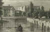
Havell, William, 1807, Reading Abbey, 566 x 823 mm. Oil painting in Reading Museum Service.
"William Havell 1782 - 1857" exhibition catalogue edited by Felicity Owen in 1981 shows this in plate 5, catalogue entry 52 page 27.
Havell, William, 1830, Reading Abbey from the Kennet, Berks, Engraving.
Man J 1816, The History and Antiquities of the Borough of Reading, Reading
Map of Reading 1834.
Speed's map of Reading in 1610
Survey of Reading 1853.
Ordnance Survey 1879, Map of Reading, scale 6" to 1 mile
Tomkins 1797 South entrance of the cloisters, view no 6.
|